NASA's Total Solar Eclipse Maps Show Best Viewing Spots (Photos)
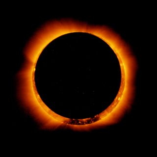
Path of a solar eclipse
On Aug. 21, 2017, a once-in-a-lifetime celestial event will give Earthlings across the United States a dazzling sight (through protective eye gear, of course). On that day, the moon will pass directly between the Earth and the sun, and as it does so it casts a shadow on Earth. The part of the shadow that obscures our planet is called the umbral shadow, or the umbra. For people who are standing on the parts of the planet within the umbra get to see a total solar eclipse — the magnitude is 1.0 or greater. But if you are outside the path of the moon's full shadow or umbra then you see varying magnitudes of the solar eclipse. Here's a look at the path of the total solar eclipse, called the Great American Total Solar Eclipse, by state, so that you can make plans to be in the best spot for the spectacle. Make sure if you do look at the eclipse that you do so through protective eclipse viewers.
Global viewing
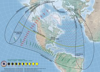
While the United States is the best place to be for viewing this eclipse, the moon's shadow will block out bits of the sun for other places as well.
Oregon
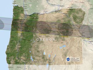
In Oregon, the cities of Salem, Madras, Culver, Warm Springs, John Day and Baker City should get about 2 minutes of this spectacular total solar eclipse view. Other Oregon cities, such as Redmond and Corvallis, while still in the umbra’s path, may have shorter viewing times.
Montana
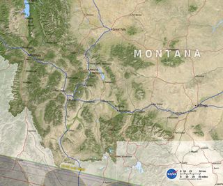
The path of the total solar eclipse will move west to east over the course of Aug. 21, 2017. Though Montana is just outside the umbra and so won’t experience the total solar eclipse, in Billings, Montana, viewers should see about 93 percent of the sun’s light masked by the moon’s shadow, reaching its peak at about 10:39 a.m. MDT, according to timeanddate.com.
Idaho
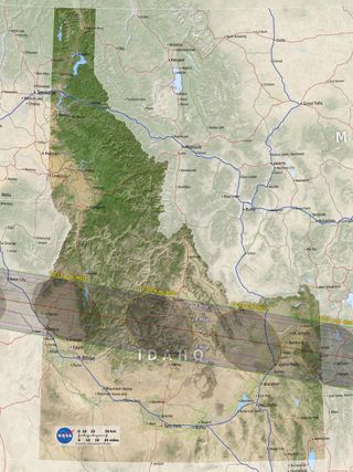
Idahoans, you are smack in the middle of the eclipse path, so grab your protective eyewear and get ready for a show. Though Boise is just outside the umbra, Idaho Falls should see a total eclipse beginning at 11:33 a.m. MDT. (Here’s more information on Idaho’s best viewing spots)
Wyoming
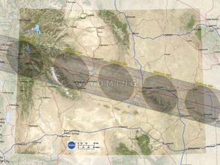
As long as the weather holds up, these Wyoming cities are smack-dab in the center of the path of totality: Glendo, Casper, Crowheart, Douglas, Evansville, Glendo SP, Mills, Pavillion, Shoshoni and Vista West, according to eclipse2017.org.
Nebraska
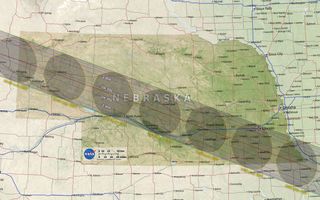
Nebraska should also have phenomenal viewing spots. The times on this map indicate the peak of totality in Central Daylight Time. For areas right in the center of the path of totality, the moon's shadow should completely cover the sun for 2 minutes and 30 seconds. According to Eclipse2017.org, the cities located along the center of the path of totality are: Alliance, Arnold, Clatonia, Filley, Gandy, Giltner, Grand Island, Hazard, Henderson, Humboldt, Lewiston, Litchfield, Mason City, Pawnee City, Pickrell, Ravenna, Salem, Steinauer, Stockham, Table Rock, Tryon and Wilber. [For more on Nebraska viewing, check out Eclipse2017.org]
Sign up for the Live Science daily newsletter now
Get the world’s most fascinating discoveries delivered straight to your inbox.
Iowa
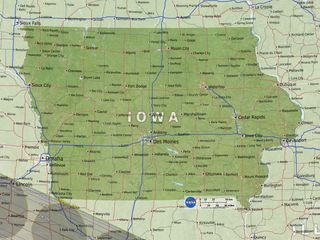
If you live in Iowa, it may be worth a drive to Missouri for the eclipse show. That's because no city in Iowa is located along the path of totality; just a smidge in the southwest of the state will be in totality.
Kansas
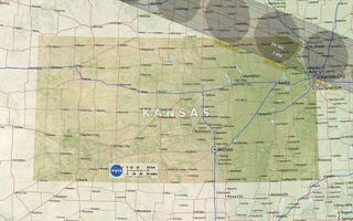
The path of totality will just nip the northeastern corner of Kansas, where cities like Highland, Troy and Wathena can expect to see the total eclipse, which should peak at about 1:06 p.m. CDT.
Missouri
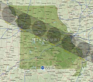
There should be plenty of places in Missouri to watch the total solar eclipse. Cities in the center of the path of totality, which should experience a total eclipse lasting 2 minutes, 30 seconds, include: Boonville, Carrollton, Charmois, Columbia, De Soto, Franklin, Gerald, Gower, Hillsboro, Lathrop, Marshall, McBaine, Mokane, New Franklin, Norborne, Parkway, Pevely, Plattsburg, Rocheport, St. Clair and St. Joseph, according to Eclipse2017.org.
Illinois
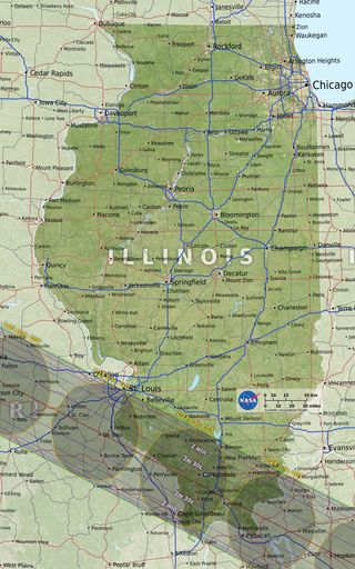
If you live in Illinois, you may want to head to Carbondale, where, just a few miles south, the eclipse will reach its point of greatest duration, starting at 1:21 p.m. CDT, according to the Southern Illinois University Carbondale campus, where NASA has partnered with the university and other agencies to lots of festivities for the day.

Jeanna served as editor-in-chief of Live Science. Previously, she was an assistant editor at Scholastic's Science World magazine. Jeanna has an English degree from Salisbury University, a master's degree in biogeochemistry and environmental sciences from the University of Maryland, and a graduate science journalism degree from New York University. She has worked as a biologist in Florida, where she monitored wetlands and did field surveys for endangered species. She also received an ocean sciences journalism fellowship from Woods Hole Oceanographic Institution.

