Louisiana braces for its 3rd dangerous hurricane in only 6 weeks
People in Louisiana are still living in tents after Hurricane Laura made landfall in August.

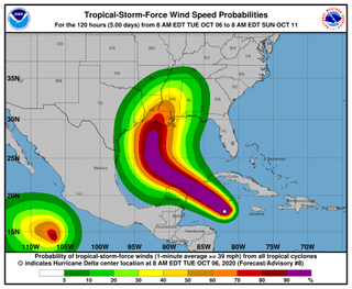
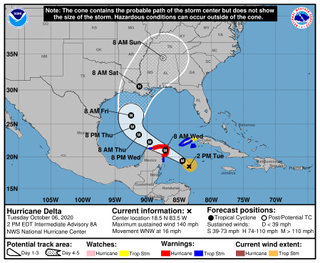
Hurricane Delta is whirling toward the Gulf Coast and is forecast to approach Mexico's Yucatan Peninsula tonight (Oct. 6) as a Category 4 storm before threatening Louisiana and Mississippi Friday (Oct. 9). This 25th-named storm is yet one more sign that climate change is brewing more active hurricane seasons.
Delta is the fourth tropical cyclone to form since the National Hurricane Center (NHC) exhausted its prepared list of 21 names and began using letters from the Greek alphabet. Delta strengthened rapidly between yesterday (Oct. 5) and today, reaching maximum wind speed of 115 mph (185 km/h) by 11 a.m. EDT this morning, making it a Category 3 storm on the Saffir-Simpson hurricane scale. The hurricane is expected to strengthen further, reaching 140 mph (225 km/h) by 11 p.m. EDT tonight, or Category 4 status. When it makes landfall in the United States, the NHC predicts peak wind speeds of 125 mph (200 km/h), again in the Category 3 range.
Wind is only part of the story though. As with most hurricanes, Delta will be most dangerous as a source of flooding.
Related: A history of destruction: 8 great hurricanes
An "extremely dangerous" storm surge is likely along the Yucatan Peninsula, where heavy rains will cause further flooding until midweek, according to the NHC. People in the area should watch out for "significant" flash flooding and mudslides.

A "life-threatening" storm surge is also likely along the Louisiana and Mississippi coasts when Delta arrives, the NHC warned. And driving rain could cause flash floods as far inland as Tennessee and as far afield as the Cayman Islands and Cuba.
Right now, the hurricane is not expected to seriously impact Florida, because a high pressure "ridge" over the state will likely steer Delta northwest and off its current track, the NHC said. The details of how this turn happens will be important, and will probably determine where exactly the hurricane makes landfall.
Sign up for the Live Science daily newsletter now
Get the world’s most fascinating discoveries delivered straight to your inbox.
Delta will be the second tropical cyclone and first hurricane named with a Greek letter to impact the mainland United States. The NHC ran out of names only once before, in 2005 — previously the most busy storm year on record. No Greek-letter-named storms reached the mainland that year. This year, Tropical Storm Beta made landfall in Texas as a relatively weak storm that killed one person and created an emergency in an area stretching from Texas to Louisiana, which was still reeling from the more devastating Hurricanes Laura and Sally.
As of last week, some people in the worst-hit Lake Charles region of western Louisiana were still living in tents as a result of those hurricanes, according to WTVY. It has been 40 days since Hurricane Laura caused a 6-foot (1.8 meter) storm surge in the state, widespread flooding and power outages. Thirty-two out of the 77 people Laura killed died in Louisiana.
Climate change is making hurricanes stronger than they were even decades ago, as Live Science previously reported. And if current trends continue, 2020’s hurricane season will blow 2005 out of the water.
In 2005, the 25th named storm of the year was Gamma. (It wasn't named Delta because meteorologists missed a cyclone beforehand and thought Gamma was the 24th storm.) The 2005 Tropical Storm Gamma didn't form until Nov. 15 — 41 days later in the season than this year’s Hurricane Delta, which formed on Oct. 5.
By the time Zeta formed on Dec. 30, 2005 — the final storm of that season — 2005 had seen 28 storms. With nearly three months to go before that date, the 2020 season has already seen 25.
Originally published on Live Science.

