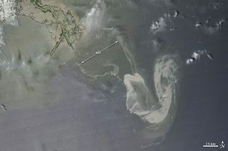
Gulf Oil Spill Spread Seen from Above

The spread of the oil spill in the Gulf of Mexico was surveyed from space by a NASA satellite over the weekend.
The oil from the explosion and sinking of the Deepwater Horizon oil rig has continued to flow out across the Gulf waters, edging closer to the fragile coastal wetlands of Louisiana.
A new image from NASA's Aqua satellite shows the extent of the slick on May 9.
The most concentrated part of the slick appears as a silvery, distorted U-shape in the right-hand side of the image. In the north-south direction, the longest part of the U stretches 53 miles (86 kilometers); from east to west, the U is about 34 miles (54 km) wide.
Tentacles of oil (which appear a faint gray in the image) reach out about 32 miles (52 km) from the main slick toward the west and about 29 miles (46 km) north-northwest.
Efforts to staunch the flow of oil with a huge containment dome failed over the weekend.
- Top 10 Worst Oil Spills
- Images: SOS! Major Oil Disasters at Sea
- Anatomy of the Gulf Oil Spill
Sign up for the Live Science daily newsletter now
Get the world’s most fascinating discoveries delivered straight to your inbox.

