Hot plumes that tower above some hurricanes presage stronger winds at the surface, NASA researchers said today.
Using a satellite last summer to study hurricane Rita from above, scientists discovered that towering clouds near the storm's eye were good predictors of future storm strength.
If rain falls from clouds soaring to 9 miles high, and the rain persists, winds at the surface are likely to get stronger, the study concludes.
Latest Videos From
Specifically, if hot towers are active at least 33 percent of the time during a three-hour period, surface winds have an 82 percent chance of intensifying. Making such measurements on the fly could improve the forecast of a storm's strength just prior to landfall.
"The trick is to keep an eye on the height of rain that radars see when a hurricane approaches within 200 miles of the coast," said study leader Owen Kelley of NASA's Goddard Space Flight Center.
Land-based radars cannot monitor storms when they are farther offshore.
The research, announced today by NASA, was detailed last year in the journal Geophysical Research Letters. The method used data from the Tropical Rainfall Measuring Mission (TRMM) satellite coupled with radar data gathered from Earth's surface.
"We've found a new way to use data that's collected all the time by weather radars on the ground," Kelley said.
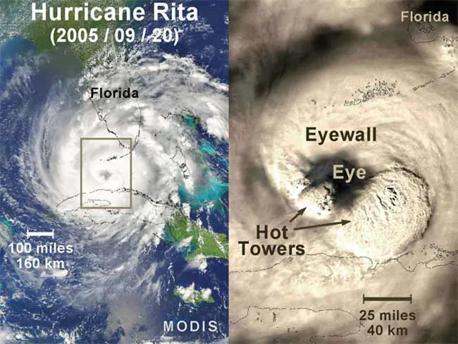
The center of any healthy hurricane has a well-defined eye that is typically cloud-free. The fiercest winds are in the eyewall, immediately surrounding the eye. In some hurricanes, towers of warm, moist air rise up through the eyewall and protrude from the storm top.
Scientists are still seeking an explanation for why and how the towers form.
Hurricane Rita had the fourth-lowest central pressure ever recorded in the Atlantic basin as it moved over warm waters in the Gulf of Mexico last September. It was a Category 3 hurricane when it came ashore near the Texas/Louisiana border.
Hurricane season begins June 1 and forecasters predict another busy year.

 Live Science Plus