
 Live Science Plus


Expedition Explains Strange Antarctic Megadunes
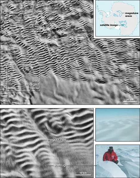
Huge frozen dunes create corduroy-like snow patterns that stretch across the Antarctic landscape. From space, the ripples resemble giant fingerprints.
But you'd be excused for missing them if you explored the continent from the surface.
"People had driven over them for many years, but didn't recognize them," said Ted Scambos of the National Snow and Ice Data Center and a glaciologist at the University of Colorado. "In the midst of them you can hardly see that there's topography, much less dunes. It's mega in scale, but the waves are extremely gentle."

Although the snowdrifts, known as megadunes, range up to eight meters (26 feet) high, their crests are up to 4 miles (6 kilometers) apart.
Only now, in a new expedition to the bottom of the world, have scientist begun to grasp these strange structures. And they're still not sure exactly how they form.
Not like sand dunes
The snowy megadunes might bring to mind giant sand dunes found in deserts, but their construction is quite different.
Get the world’s most fascinating discoveries delivered straight to your inbox.
Sand dunes are can be hundreds of yards tall, easily dwarfing their cold-climate cousins. "Also, sand dunes migrate down wind, whereas snow dunes actually climb into the wind," Scambos said.
To measure the gradual ups and downs of the megadunes, Scambos and his crew spent two seasons pulling a caravan of sleds across a frozen expanse the size of California. Besides battling frigid temperatures, the team found the terrain difficult to conquer. Smaller formations, called sastrugi, line the outer edges of the dune fields.
"They have a glassy ice surface on one side and wavelike structures of snow on the front," Scambos said. "It's like trying to climb over sandpaper -- it's extremely rough."
How they form
The dunes are created by katabatic winds -- the term for air moving downhill. The winds, ranging from 50 to 200 knots, are some of the most constant on the planet. The key to megadune building is the steady and continuous nature of the winds, Scambos explained.
The winds originate near the center of the continent, which is uphill from the megadunes. As air cools at the higher altitudes, it becomes denser. Gravity causes sheets of dense air to slide down the face of the continent.
"It's kind of like maple syrup sloughing off a pancake," Scambos said.
As the sheet slides down the ice, it picks up speed. Once it hits the plateau, the air begins to ripple. It's this slight wobbling that Scambos and his colleagues believe forms the megadunes.
The swirling air whips up snow, and over time, builds dunes. The snow packs on at a rate of less than one inch per year, so it can take a couple of centuries to build just one, and thousands of years for the dune to move from one crest to the next.
Sand dunes, in comparison, can be built up in a single sand storm. From 1954 to 1959, group of dunes in China's Ningxia Province moved more than 100 meters per year.
"If the megadunes are expanding, they're changing at a rate that's so slow we haven't been able to see it yet," Scambos said. "It's hard to say whether the dune region is expanding or if we're being fooled by the whole ice sheet moving downhill."
Messing with the record
Scientists use the Antarctic ice sheet as a history book for climate and atmospheric change over the last half million years. They do this by drilling down to harvest cores of snow and ice, then they examine the chemical changes in the layers.
But Scambos warns that cores taken from megadune regions may not tell the truth.
"Now we know that in a lot of areas these megadunes have rearranged snow and changed its chemistry," Scambos said. "The snow stays exposed to the atmosphere longer, and there is a chemical difference from the front side to the back side. We need to be careful where we drill."
One of the most famous ice cores ever drilled, the Vostok ice core, taps 11,886 feet (3,623 meters) into an area above a subsurface, liquid lake. The core may have been tainted with patches of snow and ice from megadunes, it turns out. Yet although there may be some megadune contamination, the majority of the core, which dates back nearly 500,000 years, is probably clean, said Scambos.
Strange Scene
CLICK TO ENLARGE
Credit: NASA Earth Observatory
Being There

Credit: National Snow and Ice Data Center
Amazing Images
