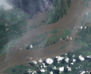
Amount of Water in Amazon Floodplain Measured from Space

When the Amazon River floods, it swells by more than half the volume of Lake Erie, the world's 15th largest lake, a new study suggests.
But this increase accounts for only 5 percent of the water flowing through the Amazon River each year, and is a much smaller rise than researchers expected to find. The study marks the first time scientists have used satellites to measure the amount of water that rises and falls annually in the Amazon River floodplain, which amounts to 68 cubic miles (285 cubic kilometers) of water.
Water volumes on any floodplain, the area of land that water spills across when a river overflows, are poorly known, if at all. Until now, researchers could only estimate the amount of water in the Amazon floodplain using a few sporadic field studies and crude assumptions about water flow. Yet this information is critical to predicting the floods and droughts that could accompany global climate change, said geologist and study team member Doug Alsdorf of Ohio State University.
"Nobody knows exactly how much water there is on the planet," Alsdorf said. "We need to understand how our water supply will change as the climate changes, and the first step is getting a handle on how much water we actually have."
The new study relied on satellite data, which could help researchers to better measure the planet's water.
"Satellite observations are the only reliable option for places like the Amazon and especially the Congo Basin, where in-person measurements are near-impossible. Just getting there is a serious challenge," Alsdorf said.
Alsdorf and his team used four satellites — three NASA satellites and one from the Japan Aerospace Exploration Agency — to get the first direct measure of water in the Amazon floodplain. They focused on measuring water level changes during the wet and dry seasons between 2003 and 2006.
Sign up for the Live Science daily newsletter now
Get the world’s most fascinating discoveries delivered straight to your inbox.
Taken together, the satellite images revealed how the Amazon landscape changed as highland rains surged through the river's many tributaries and the resulting overflow spilled into the lowland jungle. After the water receded, the team calculated the change in volume along the floodplain.
These calculations haven't been made before, in part due to the immense difficulty of combining different kinds of data in a reliable way. The researchers had to meld gravity readings — a measure of the floodwater's mass — with radar and optical measurements of the water level and extent of the floodplain.
At the height of the rainy season, water flowed into various locations on the Amazon floodplain at a rate of 190,000 cubic feet (5,500 cubic meters) per second, and during the dry season, it drained away into the Amazon River — and, ultimately, into the Atlantic Ocean — at a rate of 265,000 cubic feet (7,500 cubic meters) per second.
The study is detailed in the June 30 online edition of the journal Remote Sensing of Environment.
- 8 of the World's Most Endangered Places
- Amazon Storm Killed Half a Billion Trees
- The World's Longest Rivers
This article was provided by OurAmazingPlanet, a sister site to LiveScience.
Most Popular


