What Caused Massive Magnitude-7 Indonesian Earthquake?

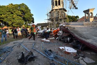
A magnitude-7.0 earthquake struck right along the coast of the Indonesian island of Lombok, near Loloan village Sunday night local time (Aug. 5), according to Indonesian authorities.
At least 91 people are reported dead from the quake, with shaking felt as far away as the island of Bali, the Associated Press reported. Damage in the north of Lombok was "massive," Sutopo Purwo Nugroho, spokesperson for the National Disaster Mitigation Agency in the area, told a news conference, as reported by the AP, that also noted the damage included collapsed bridges, blackouts and roads blocked by debris.
The U.S. Geological Survey clocked the quake as a magnitude 6.9, just shy of the magnitude registered by the Indonesian authorities. Just days earlier, on July 29, another deadly earthquake, this one a magnitude 6.4, hit the same area. That quake killed at least 16 people and injured more than 300, according to The Washington Post. Some 800 hikers were nearby when that earthquake struck and caused parts of a crater ledge and nearby plateau (holding several hikers and guides) at the summit of Mount Rinjani in Lombok to collapse into the volcano's mouth, according to news reports. [7 Ways the Earth Changes in the Blink of an Eye]
"People were climbing on top of each other because the plateau was just falling away," Mackenzie Irwin, who was at the summit during the quake event, told The Washington Post.
Both earthquakes occurred along faults in an area where tectonic plates are colliding, with one diving beneath the other.
"In this area, there's subduction, so the Australian plate is moving under the Sunda plate, and the Australian plate is moving to the north underneath the Sunda plate," Paul Caruso, a USGS geophysicist, told Live Science.
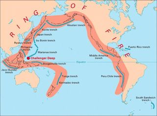
The many islands that make up Indonesia are not novices to the hazards of Mother Nature. That's because the region sits smack-dab along the so-called ring of fire — an imaginary, horseshoe-shape line that follows the rim of the Pacific Ocean and marks spots where several tectonic plates collide. These subduction zones, where one of the plates dips beneath the other during collisions, occur offshore of Washington, Canada, Alaska, Russia, Japan and, yes, Indonesia.
Sign up for the Live Science daily newsletter now
Get the world’s most fascinating discoveries delivered straight to your inbox.

"We've had a lot of really big quakes in that area," said Caruso, referring to the Indonesian region. For instance, a magnitude-7.7 earthquake and related tsunami hit off the nearby island of Java on July 17, 2006, and on June 2, 1994, a magnitude-7.8 earthquake and related tsunami hit the area, according to the USGS.
A short-lived tsunami warning was reportedly issued for some time Sunday when the quake hit, but only small waves were recorded around Lombok, according to the AP report.
According to Caruso, even though the Lombok earthquake occurred on land, it struck right along the coastline, where subsequent landslides into the sea could trigger tsunamis.
Caruso said he expects more aftershocks from the magnitude-7 earthquake, though those shocks will be of a lower intensity than the main quake.
Originally published on Live Science.

Jeanna served as editor-in-chief of Live Science. Previously, she was an assistant editor at Scholastic's Science World magazine. Jeanna has an English degree from Salisbury University, a master's degree in biogeochemistry and environmental sciences from the University of Maryland, and a graduate science journalism degree from New York University. She has worked as a biologist in Florida, where she monitored wetlands and did field surveys for endangered species. She also received an ocean sciences journalism fellowship from Woods Hole Oceanographic Institution.
