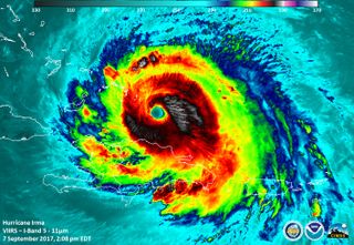
Hurricane Irma Remains Dangerous After Dropping to Category 4

On Friday morning (Sept. 8), Irma was downgraded to a Category 4 hurricane, the National Hurricane Center (NHC) reported in a public advisory. But don't relax just yet — it's still an immensely powerful and potentially deadly beast of a storm.
By 8 a.m. ET, Irma was traveling at approximately 16 mph (26 km/h) with maximum sustained winds of 150 mph (240 km/h), the NHC reported. A Category 4 storm — still considered a major hurricane — has maximum sustained winds of 130 to 156 mph (209 to 251 km/h).
Category 4 storms can inflict catastrophic damage, according to the Saffir-Simpson Hurricane Wind Scale. Such storms can tear apart roofs and exterior walls in houses, uproot trees, down power poles, and render affected areas uninhabitable "for weeks or months," according to the NHC. [Hurricane Irma: Everything You Need to Know About This Monster Storm]
At the time the advisory was issued, Irma was about 80 miles (125 kilometers) northeast of Cabo Lucrecia, Cuba, and about 450 miles (720 km) southeast of Miami. Though some wind-speed fluctuations are expected over the next few days, experts forecast that Irma will retain Category 4 strength as it bears down on Florida.
And winds are only one of the dangers faced by those in Irma's path. Storm surges as high as 20 feet (6 meters) are predicted for the Turks and Caicos Islands and for parts of the Bahamas; parts of Cuba and Florida could see surges of up to 10 feet (3 m), according to the NHC advisory.
Drenching rainfall is also on the way, with up to 20 inches (51 centimeters) forecast for parts of the Bahamas, Cuba and southeastern Florida; as much as 16 inches (41 cm) in southern Georgia; and up to 6 inches (15 cm) in the Carolinas. Excessive rains could trigger flash flooding and mudslides, the NHC reported.
Irma was designated a Category 5 hurricane on Sept. 5 — the first Category 5 storm to form in the Atlantic since Hurricane Matthew in 2016 — with sustained winds of 175 mph (280 km/h). By Sept. 7, Irma clocked wind speeds of 185 mph (298 km/h) for 33 hours; no other hurricane had ever stayed this powerful for so long since satellite tracking of storms began in 1966, meteorologist Philip Klotzbach wrote on Twitter.
Sign up for the Live Science daily newsletter now
Get the world’s most fascinating discoveries delivered straight to your inbox.
Irma's track will likely continue on its present course for a day, turning northwest by late in the day on Saturday (Sept. 9) and decreasing somewhat in forward speed, according to the NHC. The storm's eye is expected to pass close to the northern coast of Cuba and the central Bahamas today and tomorrow, approaching the Florida Keys and the southern coast of Florida by Sunday morning (Sept. 10).
Original article on Live Science.

Mindy Weisberger is an editor at Scholastic and a former Live Science channel editor and senior writer. She has reported on general science, covering climate change, paleontology, biology, and space. Mindy studied film at Columbia University; prior to Live Science she produced, wrote and directed media for the American Museum of Natural History in New York City. Her videos about dinosaurs, astrophysics, biodiversity and evolution appear in museums and science centers worldwide, earning awards such as the CINE Golden Eagle and the Communicator Award of Excellence. Her writing has also appeared in Scientific American, The Washington Post and How It Works Magazine.

