Here's How You Can Track Hurricane Irma Online

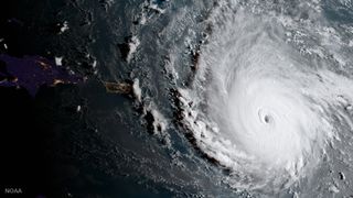
With so much online news and the smattering of social media posts on the formidable Hurricane Irma, you may find yourself at a loss for how to keep up with this Category 5 storm as it barrels toward Puerto Rico and possibly Florida.
Enter researchers at the National Oceanic and Atmospheric Administration (NOAA), meteorologists and other experts around the world who are tracking the storm. Here's how to keep tabs on what they post online, so you can keep on top of Hurricane Irma updates.
One of the best places to check is NOAA's National Hurricane Center (NHC), based in Miami. The NHC is posting weather imagery and written advisories about Irma and other active wind storms every few hours throughout the day. [Hurricane Irma Photos: Images of the Monster Storm]
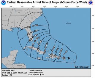
For instance, today (Sept. 6) the NHC released several images, including illustrations showing Irma's wind speed probabilities, a timetable of when it's expected to hit the landmasses in its path, the hurricane's wind history and interactive maps showing hurricane warnings. This morning, the NHC also reported that Irma is moving about 16 mph (26 km/h) toward the Virgin Islands, and has wind speeds near 185 mph (295 km/h), with higher gusts.

The internet is also awash in webcam footage, so people can watch the hurricane live — that is, unless high winds or floods disable the cameras. According to Quartz and Live Science, the following live cams can be viewed at these sites:
- Anguilla: Roy's Bayside Grill
- St. John: Great Expectations webcam
- St. Thomas: EarthCam
- Jost Van Dyke: Soggy Dollar Bar webcam
- Puerto Rico: Caribe Hilton San Juan hotel webcam
- Dominican Republic: Kite Beach Cabarete webcams
- Puerto Rico: Rabirubiaweather.com
- Florida Keys: Marathon webcam
- Florida Keys: Key West webcam and additional cams
- Miami: Miami Beach
- South Beach, Miami: Surfline.com
You can also check out the weather app called MeteoEarth, which provides a real-time look at the globe overlaid with tropical storms, wind, cloud cover and more. It also shows social media posts related to the storm and other weather.
Accuweather is updating its Hurricane Irma page with current stats and maps showing the location of the storm and its projected path.
Sign up for the Live Science daily newsletter now
Get the world’s most fascinating discoveries delivered straight to your inbox.
There are also countless updates on Twitter. Here are some folks to follow:
One user, @EUStormMap, posted, "Storm surge from #Irma has had a major effect on the Island of St-Martin, this image taken 55 min ago from inside the eye wall! #TY Chi-Chi"
The NHC is tweeting from @NHC_Atlantic, saying, "Extremely dangerous core of Hurricane #Irma closing in on the Virgin Islands. http://www.hurricanes.gov."
NASA is tweeting from a number of handles, including @NASA_SPoRT, which said, "Saint-Martin and Anguilla appear to have taken a direct hit by cat 5 Hurricane #Irma. #GOES16."
Meteorologist @EricHolthaus is also tweeting and retweeting, saying, "Getting increasingly unrealistic to expect that South Florida will escape a major impact from Hurricane #Irma."
Original article on Live Science.

Laura is the archaeology and Life's Little Mysteries editor at Live Science. She also reports on general science, including paleontology. Her work has appeared in The New York Times, Scholastic, Popular Science and Spectrum, a site on autism research. She has won multiple awards from the Society of Professional Journalists and the Washington Newspaper Publishers Association for her reporting at a weekly newspaper near Seattle. Laura holds a bachelor's degree in English literature and psychology from Washington University in St. Louis and a master's degree in science writing from NYU.

