

Winter Storm Views from Space: See the Latest Satellite Images

NASA and NOAA have their satellite eyes trained on the powerful winter storm bearing down on the U.S. East Coast this weekend, with the latest views showing the storm's growth and progress through the afternoon.
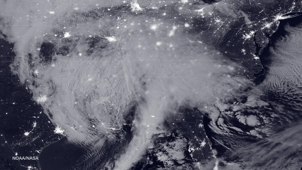
The latest space views of the winter storm from NOAA's GOES-East satellite show the U.S. East Coast as of 1:30 p.m. EST (1830 GMT) today (Jan. 22). At the time, the region was already shrouded by white clouds that stretched from Arkansas to the northeastern coast. Another view, from the powerful NPP Suomi satellite operated by NASA and NOAA, captured a snapshot of the storm before dawn today with city lights of the U.S. Southeast peeping through in infared light.

"An area of low pressure centered over the southeastern U.S. will continue developing into a major winter storm which will impact a large portion of the East Coast from the southern Appalachians through the mid-Atlantic states from Friday into the weekend," officials with the National Weather Service Weather Prediction Center said in a statement. "Snowfall totals may exceed 2 feet in portions of these areas, including the Baltimore and Washington D.C. metropolitan areas." [See more photos of the winter storm]
Using observations from GOES-East, scientists with the NASA/NOAA GOES Project at NASA's Goddard Space Flight Center in Maryland created a video animation of the winter storm over the last few days, showing the system strengthen and move eastward between Wednesday and today.
One of NASA's newest Earth observation satellites, the Global Precipitation Measurement satellite, which launched in 2014, has been regularly monitoring the amount of rainfall from the winter storm.
"A precipitation analysis was created using data collected by GPM's Microwave Imager (GMI) and Dual-frequency Precipitation Radar (DPR) instruments," NASA's Rob Gutro wrote in a storm update. "GPM's DPR saw precipitation falling at a rate of over 64 mm (2.5 inches) per hour in storms over northern Alabama."

Meanwhile, residents along the U.S. East Coast are bracing for what promises to be an epic snowfall on Saturday, with some weather services warning of potential blizzard conditions.
"The impacts from the storm stretch from the Ozark Mountains to the Mid-Atlantic," Gutro wrote. "On Jan. 22, the NWS said heavy snowfall and increasingly strong winds through Saturday are predicted to cause dangerous blizzard conditions in Washington, D.C. where blizzard warnings were in effect."
Very gusty winds across the mid-Atlantic region and Long Island, with some storm surge flooding, should also be expected, according to the National Weather Service.
While one winter storm is threatening the Eastern U.S., another weather system is affecting the Pacific Northwest, Gutro wrote. "On Jan. 22, heavy rainfall is expected in lower elevations of northwestern California and southwestern Oregon with heavy snow in higher elevations of Sierras and Washington Cascade mountain range."
You can get the latest weather forecasts and storm updates directly from NOAA's National Weather Service here: www.weather.gov.
Email Tariq Malik at tmalik@space.com or follow him @tariqjmalik and Google+. Follow us @Spacedotcom, Facebook and Google+. Original article on Space.com.

