Enormous Canyon May Be Hidden Beneath Antarctic Ice

A rift almost as deep as the Grand Canyon but much longer may be hidden beneath the Antarctic Ice Sheet.
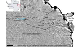
Using satellite images and radio waves, researchers have uncovered tantalizing hints of a canyon up to 0.6 miles (1 kilometer) deep and more than 680 miles (1,100 km) long. For comparison, the Grand Canyon in Arizona is 1 mile (1.6 km) deep, on average, and 277 river miles (445 km) long.
Now, they hope to confirm the discovery on the ground. "Discovering a gigantic new chasm that dwarfs the Grand Canyon is a tantalizing prospect," Martin Siegert, an earth scientist at Imperial College London, said in a statement. "Geoscientists in Antarctica are carrying out experiments to confirm what we think we are seeing from the initial data."
Siegert and his colleagues announced their initial findings online Dec. 22 in the journal Geology.
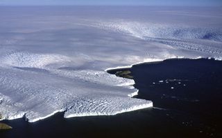
The suspected canyon is in East Antarctica, in a region called Princess Elizabeth Land. Researchers were trying to measure ice thickness in this little-explored area when they found evidence of a large river network under the glacial ice. They suspect that the network may include a previously undiscovered glacial lake up to 483 square miles (1,250 square km) in size. This possible lake and canyon network could be older than the ice sheet itself, or they could have been carved out by flowing water under the glacier, the researchers said. [Album: Stunning Photos of Antarctic Ice]

Hints of the landscape beneath the ice come from satellite data from NASA, the European Space Agency, the U.S. National Snow and Ice Data Center and other agencies, Newcastle University researcher Neil Ross, who also participated in the study, said in the statement. In addition, the International Climate and Environmental Change Assessment Project (ICECAP) has taken radio-echo soundings of the area, using the reflection of radio waves to measure geographical features. These radio-echo measurements confirm the existence of at least some canyons up to 0.6 miles deep. New radio-echo surveys will be needed to analyze the network in detail, the authors wrote in their paper.
"This is a region of the Earth that is bigger than the U.K., and yet we still know little about what lies beneath the ice," study leader Stewart Jamieson, of Durham University in the U.K., said in the statement. "In fact, the bed of Antarctica is less well known than the surface of Mars. If we can gain better knowledge of the buried landscape, we will be better equipped to understand how the ice sheet responds to changes in climate."
Sign up for the Live Science daily newsletter now
Get the world’s most fascinating discoveries delivered straight to your inbox.
Follow Stephanie Pappas on Twitter and Google+. Follow us @livescience, Facebook & Google+. Original article on Live Science.

Stephanie Pappas is a contributing writer for Live Science, covering topics ranging from geoscience to archaeology to the human brain and behavior. She was previously a senior writer for Live Science but is now a freelancer based in Denver, Colorado, and regularly contributes to Scientific American and The Monitor, the monthly magazine of the American Psychological Association. Stephanie received a bachelor's degree in psychology from the University of South Carolina and a graduate certificate in science communication from the University of California, Santa Cruz.
