
Best Earth Images of the Month - October 2012
Lights out

When Sandy's punishing winds and waves smacked into New Jersey and New York Oct. 29, they knocked out power to millions.
In the immediate aftermath of Hurricane Sandy, more than 8 million people were thought to be without power. Some 90 percent of Long Island lost power, as well as numerous communities in New Jersey and all of Lower Manhattan ?which created strange views of the island's iconic skyline from neighboring boroughs and New Jersey.
[Full Story: Sandy Power Outages Spotted from Space]
Expectations met

A striking image of Verrazano Bridge in Brooklyn as Hurricane Sandy approaches on Oct. 29, 2012.
[Full Story: Sandy Lives Up to Hype: Predictions Were on Track]
Windy effects
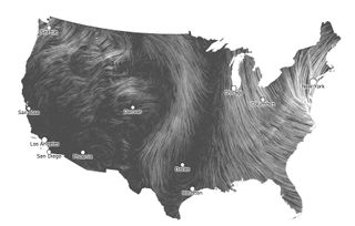
A beautiful animation just out shows Hurricane's Sandy's wind gusts as the Frankenstorm moves up the East Coast.
Screenshots taken from the map animation capture Sandy's winds advancing north last night and this morning (Oct. 29).
The map was created by Fernanda Viégas and Martin Wattenberg, artists/technologists who lead Google's "Big Picture" visualization research group in Cambridge, Mass., according to their website.
[Full Story: A Stunning Map of Hurricane Sandy's Winds ]
Remarkable monster
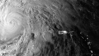
The Suomi NPP satellite caught this image of Hurricane Sandy yesterday morning (Oct. 25), just as the cyclone passed over Cuba.
In the image, you can see the hurricane's enormous size; as of 11 a.m. today (Oct. 26), Sandy boasts tropical storm-force winds, extending out to 275 miles (445 kilometers) from its center, according to the National Hurricane Center.
[Full Story: Satellite Snaps Stunning Dawn View of Hurricane Sandy]
Significant growth
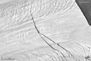
The giant fissure that was discovered last year in Antarctica's Pine Island Glacier widened and lengthened in recent months, new satellite images show.
The 18-mile-long (29 kilometers) rift foretells the start of a giant iceberg, and researchers have been monitoring the glacier since the fissure was discovered in 2011. The giant fissure was stable for several months, but in May it spawned a second crack.
[Full Story: Antarctic Ice Rift Growing, Satellite Images Show]
Cute and cuddly

The San Diego Zoo's 11-week-old giant panda cub has arrived at his "awkward toddler stage," taking his first clumsy baby steps, veterinarians at the zoo said.
During a checkup Thursday (Oct. 18), zookeepers took the cub off the exam table and let him test out his wobbly crawling skills on a mat on the floor.
[Full Story: Panda Cub Steps into 'Awkward Toddler Stage']
Hot, hot, hot
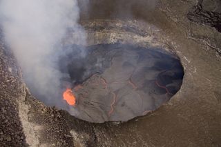
The lava lake at Kilauea's summit reached its highest level in October 2012, 150 to 165 feet (45 to 50 meters) below the floor of Halema'uma'u crater, since the vent started erupting in 2008.
[More Images: Amazing Images from Kilauea's Lava Lake]
Sign up for the Live Science daily newsletter now
Get the world’s most fascinating discoveries delivered straight to your inbox.
Odd sight
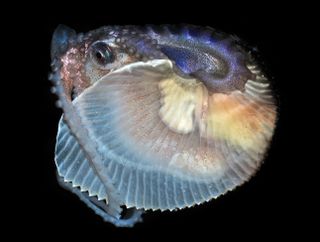
Warm ocean currents off the coast of Southern California delivered a surprise to a couple of squid fishermen this past weekend.
A female argonaut ? an octopus also called a paper nautilus ? turned up in their bait box, The Daily Breeze reported Oct. 16. The men recognized the rare find and turned it over to the Cabrillo Marine Aquarium, said Kiersten Darrow, the aquarium's research curator.
[Full Story: Rare Discovery: Tropical Octopus Caught in Los Angeles]
Under the sea (ice)

For the first time, scientists have made a 3-D map of sea ice in eastern Antarctica.
The map will help reveal the amount of ice in the region, which is important for understanding how climate change is affecting Antarctica.
[Full Story: Robot Sub Maps Underside of Antarctic Ice in 3-D]
Larger than life
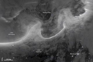
When a powerful solar flare, known as a coronal mass ejection, hit Earth's magnetic field on Oct. 8, people living in North America's northern latitudes were treated to a spectacular light show.
This visible light image from the Suomi National Polar-orbiting Partnership (Suomi NPP) satellite shows the northern lights swirling across Canada's Quebec and Ontario provinces. The city lights of Montreal also shine in the bottom of the image.
[Full Story: Image: Aurora Dips South Across Canada]
Fall colors
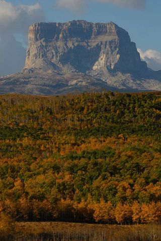
The fall foliage in Montana's Glacier National Park has arrived, in a preview of what other parts of the country can soon expect.
The National Park Service captured the above photo on Oct. 1. The fall foliage is a brilliant blend of burnt orange and dark green, with Chief Mountain looming in the background.
[Full Story: Peep the Fall Foliage at Montana's Chief Mountain]
Most Popular


