It's quick and easy to access Live Science Plus, simply enter your email below. We'll send you a confirmation and sign you up for our daily newsletter, keeping you up to date with the latest science news.
A climate pattern known as La Niña is emerging in the equatorial Pacific Ocean, supporting climate scientists' predictions for an active Atlantic hurricane season. La Niña could also bring warmer, drier conditions to southern states in the U.S. — many of which are already experiencing extreme drought.
La Niña ("The Girl" in Spanish) and its counterpart El Niño ("The Boy") are part of a climate pattern known as the El Niño Southern Oscillation (ENSO), which affects sea-surface temperatures in the central and eastern Pacific Ocean, close to the equator. During a La Niña cycle, waters in that ocean region are cooler than average.
El Niño conditions — warmer-than-average waters in the equatorial Pacific — help to suppress hurricane formation in the Atlantic Ocean. La Niña does the opposite; under La Niña, cooler Pacific waters weaken wind shear over the tropical Atlantic Basin and the Caribbean Sea, enabling more hurricanes to take shape, scientists with the National Oceanic and Atmospheric Administration (NOAA) said in a statement released on Sept. 10.
There is a 75% chance that La Niña's cooler-than-average sea-surface temperatures will persist from December 2020 through February 2021, according to the statement. La Niña conditions last appeared during the winter months of 2017 through 2018, with El Niño developing in 2018 through 2019.
A third part of the ENSO cycle — when ocean waters are neither warmer nor colder than average, sometimes called "La Nada" ("The Nothing" in Spanish) — is neutral, and does not significantly influence global climate patterns, NOAA says.
La Niña's presence over the winter months will also be felt across the U.S.; the climate pattern brings cooler, wetter conditions to northern states, while southern states will be warmer and have less precipitation than they normally do, according to NOAA.
Sign up for the Live Science daily newsletter now
Get the world’s most fascinating discoveries delivered straight to your inbox.
In August, NOAA experts predicted that the 2020 hurricane season would be one of the busiest on record. One of the factors behind that prediction was growing evidence that ocean conditions were trending toward La Niña; though La Niña doesn't actively fuel hurricanes, it doesn't suppress their formation like El Niño does, Live Science previously reported.
"Overall, the coupled ocean-atmosphere system was consistent with La Niña conditions," researchers with the National Weather Service's Climate Prediction Center said yesterday (Sept. 10) in a statement.
NOAA's August outlook predicted a hurricane season with an 85% chance of above-normal activity, capable of producing up to 25 named storms — the highest number ever predicted — with winds of at least 39 mph (63 km/h).
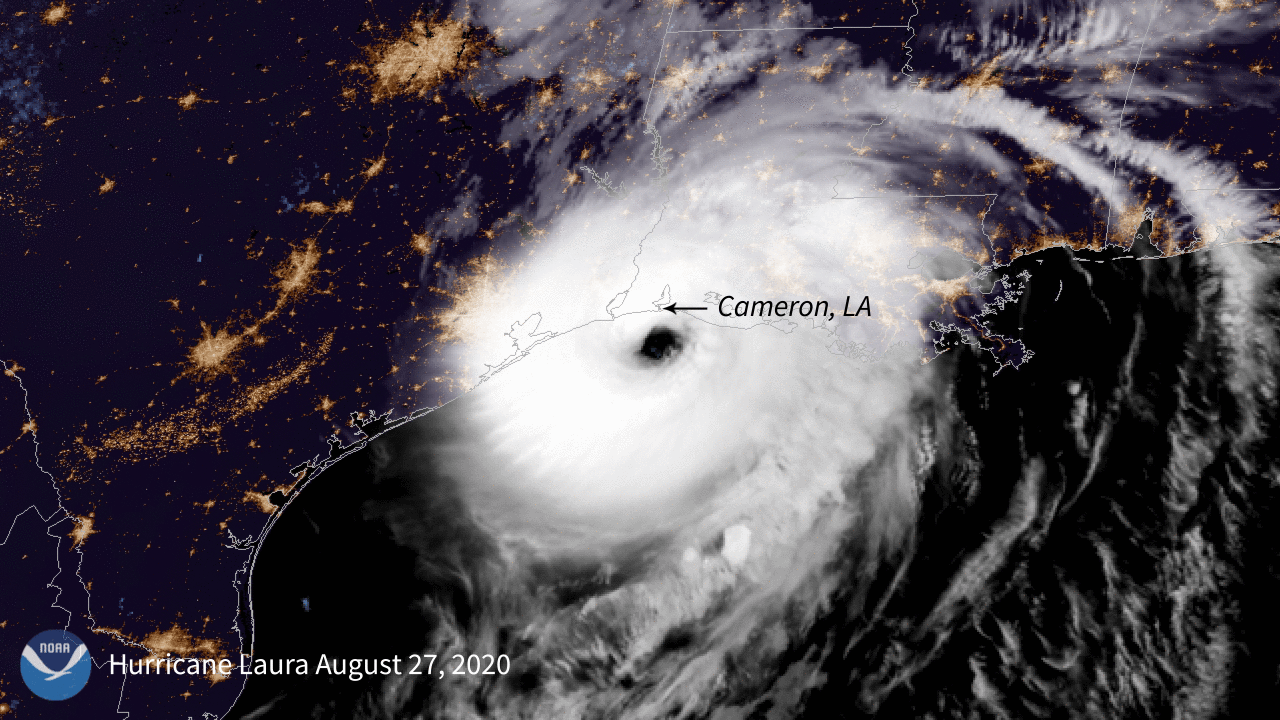
Indeed, hurricane season began early this year, with the first named storm, Arthur, forming on May 17 (the "official" start of Atlantic hurricane season is June 1). Nine named storms emerged by the end of July. The 12th storm, Hurricane Laura, barreled into coastal Louisiana on Aug. 27 as a Category 4 storm, with winds topping 150 mph (240 km/h) and a storm surge described by the National Hurricane Center as "unsurvivable," Live Science reported. It was the strongest hurricane to strike the Gulf Coast since 2005's Hurricane Katrina.
Other factors are also driving this year's unusually active hurricane season, including an enhanced West African monsoon; weaker trade winds in the tropical Atlantic Ocean; and warmer-than-average sea-surface temperatures in the Caribbean Sea and in the tropical Atlantic, NOAA scientists reported in August.
These conditions, which have persisted for decades, are thought to be responsible for more active hurricane seasons overall, dating from 1995. What's more, they show no signs of dissipating, hinting that highly active hurricane seasons will be more frequent in the years to come, NOAA's lead hurricane season forecaster Gerry Bell said in August.
"We're not seeing an end to this era," Bell said. "We're 26 years into it, and we don't know how long it's going to last."
Mindy Weisberger is a science journalist and author of "Rise of the Zombie Bugs: The Surprising Science of Parasitic Mind-Control" (Hopkins Press). She formerly edited for Scholastic and was a channel editor and senior writer for Live Science. She has reported on general science, covering climate change, paleontology, biology and space. Mindy studied film at Columbia University; prior to LS, she produced, wrote and directed media for the American Museum of Natural History in NYC. Her videos about dinosaurs, astrophysics, biodiversity and evolution appear in museums and science centers worldwide, earning awards such as the CINE Golden Eagle and the Communicator Award of Excellence. Her writing has also appeared in Scientific American, The Washington Post, How It Works Magazine and CNN.

 Live Science Plus