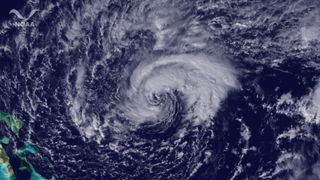
Tropical Storm Sean Swirling Over Atlantic

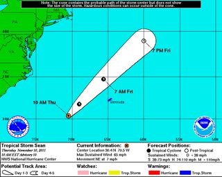
Tropical Storm Sean is moving steadily along its path toward Bermuda, though it is no longer expected to reach hurricane status.
Sean first formed on Tuesday (Nov. 8), becoming the 18th named storm of the 2011 Atlantic hurricane season . The season begins each year on June 1 and ends on Nov. 30, though storms have been known to form before and after those endcap dates.
Sean currently has maximum sustained winds of 65 mph (100 kph), just below the hurricane strength threshold, according to the latest National Hurricane Center (NHC) update. It is currently 360 miles (580 kilometers) west-southwest of Bermuda, and a tropical storm warning is in effect for the island. The storm is expected to bring between 1 and 3 inches (2.5 and 7.6 centimeters) of rain to Bermuda.

Swells and rip currents are expected to remain a hazard along the southeastern coast of the United States, the NHC warned. Rip currents have already claimed one life, according to The Weather Channel.
The 2011 Atlantic season was predicted to be an active one, with 14 to 19 named storms, including seven to 10 hurricanes and three to five major hurricanes (those of Category 3 status or higher). There have been six hurricanes so far this season and three major hurricanes.
Sign up for the Live Science daily newsletter now
Get the world’s most fascinating discoveries delivered straight to your inbox.

