
Earth's Lights at Night
London, England, United Kingdom
On Earth, we gaze up into the night sky to see the bright pinpoint-light of stars and our fellow planets. But from high above the surface, astronauts and satellites look down on us and the blotches of light created by our urban areas.
Here we see what some of Earth's major cities look like at night.
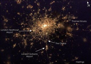
This nighttime view of the British capital offers unique insight into the city's urban density and infrastructure as highlighted by electrical lighting. Interpreting the brightest areas as the most populated, the population density drops off rapidly from the bright urban center until it reaches the vicinity of the Orbital, an encircling roadway.
Beyond lie isolated bright areas marking the numerous smaller cities and towns of the region and as far southeast as Hastings on the coast. Note London's two major airports, Heathrow and Gatwick, and the particularly bright, sinuous stretch of the Orbital to the south of the city.
The crew of the International Space Station acquired this image shortly after 7:22 p.m. local time on the evening of February 4, 2003. Either thin, low clouds or perhaps fog is evident in the fuzzy character of patterns for some of the surrounding smaller cities while that of the warmer urban center is still clear and sharp.
Los Angeles, California, United States
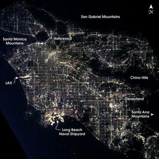
After sunset the borders of "The City of Angels" are defined as much by its dark terrain features as by its well-lit grid of streets and freeways. Over 13 million people inhabit the coastal basin bounded roughly by the Santa Monica and San Gabriel Mountains to the north and the Chino Hills and Santa Ana Mountains to the east and southeast.
The crew of the International Space Station took this unique photo shortly after 1 a.m. local time on March 10, 2003. Both the glitter and sprawl of America's second largest city as well as a number of its renowned landmarks are highly visible.
In the north, Hollywood is nestled against the south side of the Santa Monica Mountains. On the coast, Los Angeles International Airport (LAX) and the port facilities at Long Beach Naval Shipyards are bright spots. Finally, even at this time of night, the bright lights of Disneyland in Anaheim are a standout feature.
Brasília, Brazil
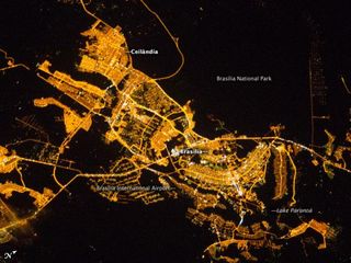
Whether seen at night or during the day, the capital city of Brazil is unmistakable from orbit. Brasília is located on a plateau the Planal to Central in the west-central part of the country, and is widely considered to be one of the best examples of 20th century urban planning in the world.
One of its most distinctive design features as seen from above suggests a bird, butterfly, or airplane traveling along a northwest-southeast direction, and is made dramatically visible by city light patterns (image center right, between Lake Paranoá and the airport).
The developed areas of Brasília and its satellites are clearly outlined by street grids and highway lights in this astronaut photograph taken from the ISS. The large unlit region to the upper right is the Brasília National Park. Other dark regions to the bottom and left include agricultural fields and expanses of the Cerrado tropical savanna. [Related: Brazilian Beauty: The Endangered Atlantic Forest ]
Montreal, Quebec, Canada
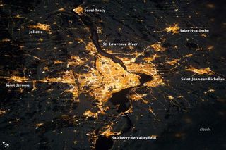
Montreal, Canada's second-largest city, is located on the Island of Montreal, at the confluence of the St. Lawrence (image center) and Ottawa rivers (not visible). The city takes its name from Mont Royal, located at the city's center. Several smaller urban areas form a loose ring around the metropolitan area: Sorel-Tracy, Saint-Hyacinthe, Saint-Jean-sur-Richelieu, Salaberry-de-Valleyfield, Saint-Jerome, and Joliette are among those that can be readily identified in this image taken by an astronaut aboard the International Space Station (ISS).
The image illustrates the extent of urbanization. Major roadways and industrial areas are traced by bright white lighting, while the adjacent residential and commercial lands are characterized by more diffuse yellow-gold lighting. Rivers and other water bodies appear black, while the surrounding countryside is faintly illuminated by moonlight. Blurry areas at image top and bottom right are caused by cloud cover.
The International Space Station was located over the Pennsylvania-New York border (near Warren, Pa.) at the time this image was taken a ground distance of approximately 370 miles (600 kilometers) southwest of Montreal.
Tokyo, Japan
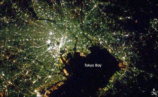
This nighttime photograph of Tokyo, Japan, was taken by International Space Station astronaut Dan Tani on February 5, 2008. [Related: What a View: Amazing Astronaut Images of Earth ]
The heart of the city is brightest, with ribbons of lights radiating outward from the center along streets and railways. The regularly spaced bright spots along one of the ribbons heading almost due west out of the downtown area are probably train stations along a public transit route.
The lights of Tokyo are a cooler blue-green color than many other world cities. The color results from the more widespread use of mercury vapor lighting as opposed to sodium vapor lighting, which produces an orange-yellow light.
Las Vegas, Nevada, United States
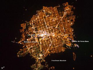
The Las Vegas metropolitan area is located near the southern tip of Nevada, within the Mojave Desert.
The surrounding darkness of the desert presents a stark contrast to the brightly lit street grid of the developed area in this ISS image. The Vegas Strip is reputed to be the brightest spot on Earth due to the concentration of lights on its hotels and casinos.
The tarmac of McCarran International Airport is dark by comparison, while the airstrips of Nellis Air Force Base on the northeastern fringe are likewise dark. The dark mass of Frenchman Mountain borders the city to the east.
Dubai, United Arab Emirates
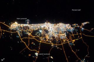
The city of Dubai is the largest metropolitan area in the emirate of Dubai, one of the member states of the United Arab Emirates. Dubai is located along the southern Persian Gulf on the Arabian Peninsula, and its signature city is known for high profile architectural and development projects.
Among the most notable is the Palm Jumeirah, a man-made peninsula and surrounding islands built from over 50 million cubic meters of sand. Three other island projects, two similar to Palm Jumeirah and another crafted to look like a map of the world , are also underway along the Dubai coastline.
This nighttime astronaut photograph of the city of Dubai was taken at approximately 2 a.m. local time on September 11, 2009. Orange sodium vapor lights trace the major highways and street grid in and around the metropolitan area, while grey-white mercury vapor lamps fill in the commercial and residential areas.
The lighted islands and peninsula of Palm Jumeirah are clearly visible along the coastline. A spiral pattern of lights on the southeastern fringe of the urban area is a camel racetrack. Nighttime images like these are useful to climate modelers, urban planners, and geographers as they allow for simple definition of urban (densely lit) and rural (sparely lit) areas.
Sign up for the Live Science daily newsletter now
Get the world’s most fascinating discoveries delivered straight to your inbox.
Milan, Italy
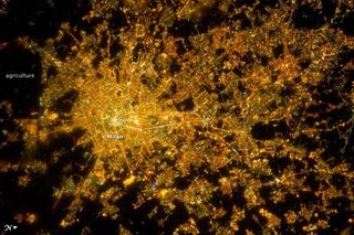
The metropolitan area of Milan (or Milano) illuminates the Italian region of Lombardy in a pattern evocative of a patchwork quilt in this ISS image. The city of Milan forms a dense cluster of lights in this astronaut photograph, with brilliant white lights indicating the historic center of the city where the Duomo di Milano (Milan Cathedral) is located.
Large dark regions to the south (image left) contain mostly agricultural fields. To the north, numerous smaller cities are interspersed with agricultural fields, giving way to forested areas as one approaches the Italian Alps (not shown). Low, patchy clouds diffuse the city lights, producing isolated regions that appear blurred.
Milan has the largest metropolitan area in Italy, and the fifth largest in the European Union.
Buenos Aires, Argentina
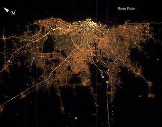
Buenos Aires is one of the larger cities seen by orbiting crews. Twelve million people, almost one third of all Argentines, live in this city, often called the "Paris of the South."
Taken very early on the morning of Saturday, Feb. 8, 2003, from the International Space Station with the handheld eclectronic still camera, this remarkably clear image shows the lights of Argentina's capital city.
Brightness of the lights exactly represents the density of the urban population, which declines all the way to the blackness of the farmlands that surround the city. The brightest area is the old part of the city centered on the port and the presidential palace, the Casa Rosada. The blackest part of the scene is the River Plate, the great estuary of the Atlantic Ocean on which this port city is located.
The widest city thoroughfare in the world the Avenida 9 de Julio with four major roads running parallel, separated by grassy swards is the brightest line in the downtown cluster. It appears as the longest north-south strip just inland of the port. Four major highways can be seen diverging from the city center. These highways may be more visible due to the well-known late-night traffic of weekend Buenos Aires.

