When Will the Horrible Heat Wave End?

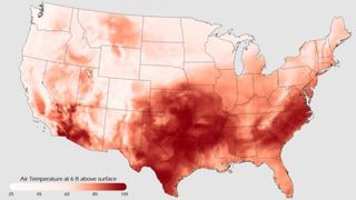
The eastern two-thirds of the United States is currently in the midst of a spell of oppressively hot and humid weather which shows little sign of breaking before the end of this month.
In some locations, the heat has been intense, with triple-digit temperatures combined with a lack of any significant precipitation which has lead to severe drought conditions . The drought, in turn, has seriously interfered with farming in the nation's heartland and across the Southern Plains.
So just what is the cause for this incredible siege of hot and dry weather?
Inflating like a balloon
Coinciding with Independence Day weekend, a ridge of high pressure both in the lower and upper levels of the atmosphere began to inflate almost like a balloon over the middle of the country. Because high pressure is associated with sinking air, air from the upper levels of the atmosphere descends and rotates outward; compression effects warm the air, as well as dry it out.
The outward flow also prevents other weather systems from moving in. Because high pressure is also associated with fair skies, cloudiness is kept to a minimum. Under clear skies, the intense sunshine can become punishing; as the air mass continues to receive insolation, its heat content is maintained. [Related: Weirdo Weather: 7 Rare Weather Events ]
{brightcove CMS_LS_15109}
Sign up for the Live Science daily newsletter now
Get the world’s most fascinating discoveries delivered straight to your inbox.
Now, nearly three weeks after it began to evolve, the upper level weather charts at what meteorologists refer to as the 500-millibar level an altitude of roughly 18,000 feet show a tremendously large, closed high pressure system enveloping much of the nation's midsection. And anytime such a weather feature becomes established, weather forecasters know that there will be only very slow changes in the weather, because there are no upper winds to steer the high pressure system away. And the longer the high remains there, the hotter and increasingly humid air is pumped up from the Gulf of Mexico.
Records being set
The core of the most extreme heat has been centered over Oklahoma and northern Texas. On Monday (July 18), at Oklahoma City's Will Rogers World Airport, the high temperature hit 101 F (38.3 C), marking the 28th day this year of 100 F (37.8 C) or above temperatures . It seems that this city is on track to break its all-time record of 50 days at or above 100 F set in 1980, as the extreme heat shows little sign of abating any time soon. To the north, in the city of Enid, the searing temperatures caused asphalt at a major intersection along U.S. Highway 412 to buckle last Saturday evening (July 16).
But as hot as it has in central Oklahoma, in the western Oklahoma counties of Beaver, Texas and Cimarron, temperatures in excess of 110 F have been the norm since July began.
Meanwhile, in the neighboring state of Texas, researchers at Texas A&M University have just determined that during the period running from February through June, the statewide average precipitation measured a paltry 4.26 inches (10.8 centimeters), making this the driest stretch of weather for this six-month stretch ever recorded in the Lone Star State, besting the old February to June record of 6.45 inches (16.38 cm) set in 1917.
When will it end?
For the balance of this week, it appears that the hottest temperatures now centered over the central United States will be spreading eastward. A small bubble of slightly drier and slightly cooler air might temporarily hold the heat at bay over parts of the Northeast during Tuesday and Wednesday, but by Thursday, the extreme heat will be working its way into New York State and New England and as the week comes to a close on Friday, triple-digit temperatures will be possible even into parts of Vermont, New Hampshire and Maine. Meanwhile the central states will continue to broil with no relief in sight.
Looking into the proverbial meteorological crystal ball from now through the balance of the summer season, the Climate Prediction Center (CPC) is forecasting a continuation of hotter-than-normal temperatures across the Desert Southwest and points east across the Deep South. Below-normal temperatures are forecast over the Northern Rockies and Northern Plains, where wetter-than-normal conditions are anticipated. Above normal precipitation is also forecast for much of Florida and near and along the Southeast and Middle Atlantic States.
The CPC also notes that while atmospheric circulation anomalies still reflect aspects of La Niña, which had a significant impact on last winter's weather across the nation, sea surface temperatures across the equatorial Pacific Ocean have now reverted back to near-average , a condition that is expected to continue into the upcoming fall season.
Beat the heat
A weather palindrome perhaps says it best: Too hot to hoot.
So until a significant pattern change in the atmosphere occurs and by the looks of things that likely won't happen before August arrives you can try to beat the heat by slowing down. Even those who become acclimated to the heat and are in good health should stop strenuous activities or wait until the coolest part of the day (usually early in the morning). Spend as much time as possible in air conditioned places.
Elderly people or others most in danger from the heat should stay in the coolest place possible. Check to see if there are any cooling centers available in your town or community.
Most Popular


