Welcome to the 'Land of Terror'

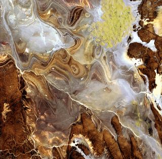
The image shows the extraordinary landscape of the Tanezrouft Basin, one of the most desolate parts of the Sahara Desert, in south-central Algeria. The region is known as 'land of terror' because of its lack of water and vegetation.
Most of the face of the Sahara stretching across Northern Africa is bare stone and pebbles rather than sand. With little vegetation present, the landscape is modified by strong, nearly constant wind erosion.
As visible, this region is characterized by dark sandstone hills, steep canyon walls, salt flats (white), stone plateaus, sandstone outcrop patterns of concentric loops and sprawling seas of multi-storey sand dunes known as 'ergs'. Erg Mehedjibat, which appears as a yellow bouquet of flowers (upper right), is made up of a cluster of small star dunes that grow upward rather than laterally.
Occupying approximately 10 percent of the African Continent, the Sahara is the largest desert in the world. It covers an area of about 9 million sq km over parts of Algeria, Chad, Egypt, Libya, Mali, Mauritania, Morocco, Niger, Tunisia and the Sudan.
The Algerian Sahara makes up more than 90 percent of the country's total area. Major oil and natural gas deposits lie beneath the Sahara's surface, contributing to Algeria's position as one of the wealthiest African nations. As large as the whole of Western Europe, Algeria is the second-largest country in Africa, after the Sudan.
- Saharan Dust Hangs in Skies Near Portugal
- 'Stone Forests' of the Sahara
- Tin Bider Crater Has Tricky Topography
Sign up for the Live Science daily newsletter now
Get the world’s most fascinating discoveries delivered straight to your inbox.
Most Popular


