Winter Hangover: Spring Floods Threaten U.S.

As if the looming tornado season was not enough, large swaths of the United States could see severe flooding this spring, according the updated spring flooding forecast, released by the National Weather Service (NWS) last week (Feb. 24).
Spring is usually prime time for tornadoes . Tornado season begins in March and peaks from May to June. But because of this winter's brutal snowstorms and cold temperatures, the spring melt could overwhelm rivers across the country, as folks in Indiana saw this week.
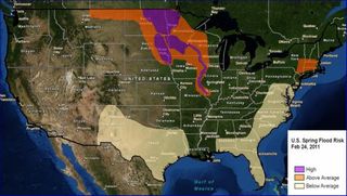
Much of the North Central United States is at risk of major spring flooding, the forecast predicts. The North Central risk area runs from northeastern Montana through western Wisconsin and along the Mississippi River south to St. Louis.
For the third consecutive year, forecasters predict major flooding along the Red River of the North , which forms the state line between eastern North Dakota and northwest Minnesota. Other areas of the Midwest primed for major flooding include Devils Lake in North Dakota, the Milk River in northeastern Montana, the James and Big Sioux Rivers in South Dakota, the Minnesota River, and the Mississippi River from its headwaters near St. Paul, Minnesota, downstream to St. Louis. Spring flooding has already hit southern Indiana , where snow melt and 12 days of rain filled the region's rivers and triggered flooding in the upper Mississippi Basin.
Parts of the Northeast have an above average flooding risk, including southern New England and the Catskill Mountains in New York. October and November rains in these areas soaked the soil, and then whopper winter storms bought above average snowfall and river icing. If heavy rains fall when the snowpack melts, the rivers and streams could spill over the watersheds, triggering floods .
Texas and New Mexico do not have to worry about flooding this year. A below average risk of flooding exists in most of these states, and along most of the Mid-Atlantic, Southeast and Gulf Coast. Precipitation and soil moisture in these areas are now well below average.
Late February is too early to determine spring flooding risk for the Western United States, according to the forecast. The complete national forecast will be issued March 17.
Sign up for the Live Science daily newsletter now
Get the world’s most fascinating discoveries delivered straight to your inbox.

