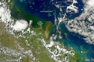
Australia Floods Wash Soil into Sea Near Great Barrier Reef

In December 2010 and January 2011, swollen rivers in Queensland, Australia, did more than flood homes and force residents to evacuate. The rivers also carried heavy sediment loads to the coast, according to a NASA statement.
Fed by the Burdekin River, the waters around Cape Bowling Green turned muddy brown in early January, and a thick plume of sediment neared the Great Barrier Reef . The Moderate Resolution Imaging Spectroradiometer (MODIS) on NASA's Aqua satellite captured this natural-color image of the coast on Jan. 4, 2011.
The Queensland Government has identified poor water quality as an ongoing challenge to coastal environments. Heavy doses of nutrients such as nitrogen and phosphorus common in fertilizers increase the risk of harmful algal blooms (commonly known as red tide), which can prompt the closure of fisheries and swimming areas.
Heavy sediment loads also cloud the water, interfering with photosynthesis in marine plants and smothering some organisms. In its Great Barrier Reef Water Quality Protection Plan, the regional government has made it a priority to reduce sediment and nutrient runoff to the ocean.
Sign up for the Live Science daily newsletter now
Get the world’s most fascinating discoveries delivered straight to your inbox.
Most Popular


