Summer 2012 In Running for Hottest Summer on Record

This article was provided by AccuWeather.com.
The summer of 2012 is in the running for one of the top three hottest summers in the past 60 years in the United States and southern Canada.
Steven A. Root, Certified Consulting Meteorologist and President and CEO of WeatherBank, Inc. has been examining hourly and daily temperatures in 59 hub cities dating back to Jan. 1, 1950.
WeatherBank is an AccuWeather, Inc. long-range forecasting and data partner.
Root computes the cooling degree days (CDD) for each city, each day of the year. Cooling degree days are the number of degrees that a day's average temperature is above 65 degrees. The period from May 15 to Sept. 15 is considered to be the air conditioning/cooling season for the U.S. and Canada.
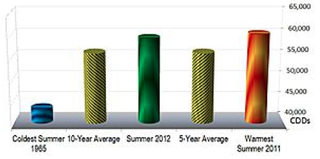
Root is estimating this summer to finish up with 59,484 CDDs based on what has happened thus far and what is projected.
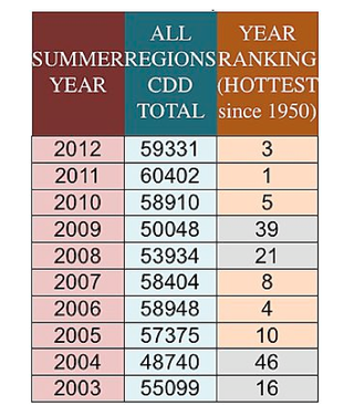
"The summer of 2012 is on pace to finish third hottest on the list of 62 summers since 1950, but is still in the running for number two or one on the list," Root said.
Sign up for the Live Science daily newsletter now
Get the world’s most fascinating discoveries delivered straight to your inbox.
The hottest summer on Root's records was last year (2011) with 60,402 CDDs. The second hottest summer, according to Root was 1951 with 60,078 CDDs. Comparatively, the coolest summer was 1965 with 43,337 CDDs.
Root's approximate 60-year average is 51,923 CDDs. The commonly used National Oceanic and Atmospheric Administration's (NOAA) most recent 30-year average is 53,933 CDDs. In the past 10 years, the average CDDs is 56,134.
"This tells you that the summers are trending hotter in the most recent decades and years for the U.S. and southern Canada as a whole," Root said.

In the U.S. as a whole, seven out of the last 10 summers have been hotter than the 62-year average. This compared to the 1960s and 1970s, when seven out of 10 summers were cooler than the NOAA's recent 30-year average.
During the 1980s and 1990s, again in the U.S. as a whole, the number of summers were about a 50/50 split being warmer or cooler than the NOAA 30-year average.
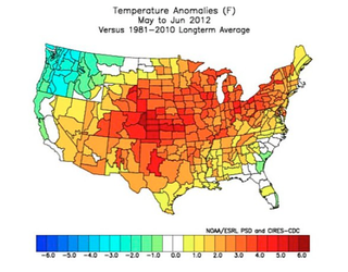
It is important to note that during an average summer across the U.S. and southern Canada, one part can be and often is significantly warmer or cooler than the local average.
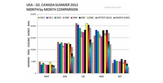
Last summer, heat got a later start, compared to this summer. Root expects the period through Sept. 15 to fall a bit behind last year's pace and it is for that reason that this summer will probably fall a bit short of last year in terms of total CDDs.
"It will still be close and another big, broad surge of extreme heat can push the summer over the top in terms of CDDs," Root said.

According to AccuWeather.com's long-range forecasting department, headed by veteran meteorologist Paul Pastelok, "We expect more surges of heat to build out of the Plains and into the East in the coming weeks."
"While cooler and potentially wetter conditions are projected to expand in the West, the most extreme warmth, relative to normal, could be forced out of the Plains and take root in the Great Lakes and Northeast, during September and October," Pastelok added.
Root and Pastelok agreed that dry soil conditions and existing extreme warmth could continue to skew averages through the remainder of the summer over much of the country, into the fall and so on.
Only when sufficient soil moisture returns will things begin to behave as they should.
Soil moisture takes energy away from the sun, so that less of the sun's energy is available to heat the ground and the air nearest the ground.

How Does Root Estimate the Reminder of the Summer?
First, all available computer models in the public and private sector are examined.
Next, all past years are examined and the top candidates for similar-looking weather and temperature patterns to this summer are pulled and weighted in. These are known as analog years.
Finally, the analog years are adjusted by shifting the start of the season forward and backward to account for potential late-starting or early-starting summer patterns.
In the 15 years Root has been making seasonal weather projections, he has run into some problems in the most recent years, due to more extremes in temperature (hot and cold) than during the prior years.
"In the recent five years, I have had to manually override the data due to the high number and magnitude of temperature extremes, compared to prior decades," Root said.
Root chose 1950 as the starting point since this is when a high number of the reporting stations throughout the U.S. and southern Canada began recording hourly temperature data.
"Even with this starting point we had to create a few virtual weather stations for the first few years, based on knowledge of weather in the missing locations, relative to surrounding actual stations," Root said.
AccuWeather Enterprise Solutions (AES) provides ag-focused forecasts from expert agricultural meteorologists that help manage risk, highlight opportunity and increase profitability.
AES works directly with your company to provide the long-range predictions that impact yields including seasonal, planting, harvesting and drought forecasts. It also provides timely warnings for severe weather, including hail, frost, thunderstorms, extreme heat and cold and more for growing regions around the world.
For more information, contact us at 814-235-8600 or email sales@AccuWeather.com.
© AccuWeather.com. All rights reserved. More from AccuWeather.com.
