Wave of Destruction: Asian Tsunami Disaster
Kalutara, Sri Lanka (Before)
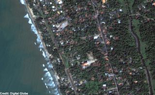
This image shows the area detail of the coast of Kalutara, Sri Lanka prior to the Tsunami disaster. This before photograph was taken almost a year earlier, on January 1, 2004.
Map Overview: Earthquake Spawns Tsunamis
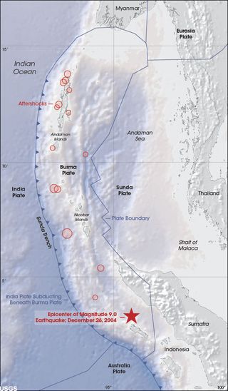
The Earth’s solid surface floats on a layer of softer rock as a collection of interlocking, movable puzzle pieces called tectonic plates. At 7:58 a.m. (local time), on December 26, 2004, beneath the Indian Ocean west of Sumatra, Indonesia, pent-up energy from the compressional forces of one tectonic plate grinding under another found a weak spot in the overlying rock. The rock was thrust upward, and the Earth shook as a 9.0 magnitude earthquake sent its vibrations out into the ocean. The epicenter of the recent quake is marked with a red star in the image. The blue arrows along the plate boundary show the direction of subduction. Tsunamis spread out in all directions; the massive waves washed over islands and crashed against coastlines in Sri Lanka, Southern India, and even the east coast of Africa.
Moment of Impact: Kalutara, Sri Lanka
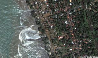
This natural color, 60-centimeter (2-foot) high-resolution QuickBird satellite image, shows receding waters from the Tsunami, which struck on December 26, 2004, on the southwestern coast of Sri Lanka. Imagery was collected at 10:20 a.m. local time, slightly less than four hours after the 6:28 a.m. (local Sri Lanka time) earthquake and shortly after the moment of tsunami impact.
Beach Damage: Kalutara, Sri Lanka
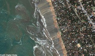
This natural color, 60-centimeter (2-foot) high-resolution QuickBird satellite image of the southwestern coast of Sri Lanka, shows the receding waters and beach damage from the Tsunami. There was extensive coastline flooding, high water was evident at least a kilometer inland, and churning ocean resulted from the receding water.
Tsunami Waves Pound Malaysia
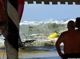
In this photo taken by a tourist Eric Skitzi from England, tourists watch as tsunami waves hit the shore from a safe place inside Casuarina Beach Hotel resort in Penang, northwestern Malaysia around 1:00pm in local time (0500GMT) Sunday, Dec. 26, 2004. The resort hotel lifeguards noticed waves were huge and sounded warning to all tourists around the hotel beach area to run to the safety area. The Malaysian government on Wednesday canceled New Year celebrations nationwide, urging people to pray this weekend that the country will be spared from future disasters such as the recent tsunamis that killed at least 65 Malaysians.
Killer Waves Approaching
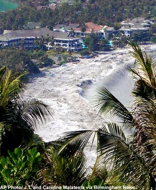
Caroline and J.T. Malatesta of Mountain Brook, Ala. survived the killer Asian tsunami while on vacation in Thailand. This mountain top photo was taken December 26, 2004 from about 400 feet above the sea on December 26, 2004.
Water Flows through the streets of Sri Lanka
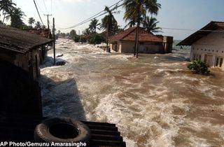
Tidal waves wash through houses at Maddampegama, about 60 kilometers (38 miles) south of Colombo, Sri Lanka, Sunday, Dec. 26, 2004. Massive waves triggered by earthquakes crashed into villages along a wide stretch of Sri Lankan coast on Sunday, killing more than 2,100 people and displacing a million others.
Sign up for the Live Science daily newsletter now
Get the world’s most fascinating discoveries delivered straight to your inbox.
Aerial Photos Reveal Ruin
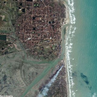
Space Imaging's IKONOS satellite took this high-resolution satellite image of Nagappattinam, India December 29, 2004. The image shows the extensive flooding and mass destruction of the land area. India, along with Indonesia, Sri Lanka, and Thailand was among the countries that suffered the worst damage due to the Tsunami. The port city, also called Negapattinam, is situated on the low plain of the Coromandel Coast, in central Tamil Nadu state, 260 km (162 mi) south of Chennai (Madras). Although Nagappattinam has only a small wharf, the port is an important one of the Kaveri delta. The city's population is about 90,000.
Wrath of Tsunami Ravages Male International Airport
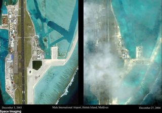
Before and after satellite photos show extent of tsunami damage at Male International Airport in the Maldive Islands located south of India. The comparative photos were taken by Space Imaging's Ikonos remote sensing spacecraft. The "after" image is cloudy and hazy so the level of detail is not as good as in the "before" image. Male is the capital of the Maldives. The imagery shows sand and debris on the runway, debris and damage to the coastline, damage to the boat marina located near the airport, and damage to structures on the sand jetties. The airport is located in the center of a small island called Hulule and is the first point of contact for every visitor coming from overseas.
Tsunami Destroys Lhoknga, Indonesia
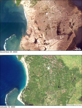
The Indonesian province of Aceh was hit hardest by the earthquake and tsunamis of December 26, 2004. Aceh is located on the northern tip of the island of Sumatra. On December 29, estimates of the death toll in Indonesia were over 80,000—more than half the global total. The town of Lhoknga, on the west coast of Sumatra near the capital of Aceh, Banda Aceh, was completely destroyed by the tsunami, with the exception of the mosque (white circular feature) in the city’s center. The satellite images show Lhoknga before (lower/left) and after (top/right) the earthquake and Tsunami. Almost all the trees, vegetation, and buildings in the area were washed away. Behind the town, low-lying agricultural areas remained covered with water four days after the disaster, and sand on the nearby beaches was completely removed. The wave height might have exceeded 15 meters (50 feet) when it struck the shore.
A City in Ruin
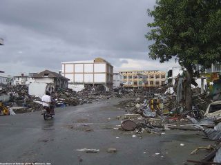
Two children ride a bike along the roads of Aceh, Sumatra, Indonesia (Jan. 1, 2005) - Trash and debris line the streets while locals check on the aftermath in down town Aceh, Sumatra following a massive Tsunami that struck the area on the 26th of December 2004.
